te139.
map/
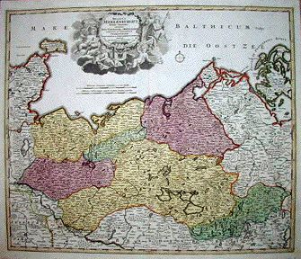
Germany put into the basket Homann, Johann Baptist: Ducatus MEKLENBURGICI Tabula Generalis continens Duc: VANDALIAE et MEKLENBURG Comitatum et Episcopatum.
Nürnberg. 1730. hand colored copper engraving.
size: 49x57 cm.
page: 52x59 cm.
intact margin.
price: 115.38 EURO
Decorative and highly detailed regional map, extending from Holstein and Lubeck in the west to Rugia and Pomerania in the east, and centered on Mecklenburg, Swerinensis, Vandalia, Rostochiense and Stargardiense. Principal cities include Schonberg, Wismar, Lavwenburg, Swerin, Gurstrow, Goldberg, Sterneberg, Lubitz, Waren, Niestat, Grabow, Eldena, Bruel, Waldehagen, Plawe, Varchow, Pentzlin, Mirow, Starlow, Arensberg, Walde, Tessin, Rostok, Kropelin, N. Bukow, Doberan, Ribnitz, Marlow, Grubenhagen and Old Kalen. Large decorative cartouche.


